For Farmers
Do you want to :
- find groundwater?
- reduce pumping costs and influence on neighbouring bores?
- find and repair seepage from your ponds and channels?
- transform your seepage into water storage, evaporation free? or
- map soil to increase water use efficiency.
- map soil for farm planning.
- map soil for water storage design.
We can help farmers with these tasks by providing:
- Water bore investigations. We create easy-to-visualize water bore graphics interpreted from drillers logs stored in government databases. 3D graphics, viewed by farmers and us in Google Earth, helps as a first step to understanding groundwater resources at farm scale. Using this information we can quickly offer some advise without the cost of site visits and geophysics (see ‘Graphics‘ page). Site visits with geological mapping and/or geophysics may follow or investigation may logically be directed back to the farmer and/or driller.
- Groundwater Investigation using towed transient electromagnetic survey - Wallaby and Wallaroo electromagentic instruments reveals variations in geology at 10’s of metres deep, variation from clay to sand and gravel, or hard rock as well as variation in groundwater salinity and saturation. Read more about ‘Towed TEM for farmers’ below and read ‘Testimonials’. (Other links – ‘Land based’ and ‘AgTEM’ pages),
- HERBI geophysical surveys investigating seepage from irrigation storages and channels. With a little additional cost, sonar, precise GPS and laser scanners in HERBI may soon also measure dimensions used with level monitoring (eg. Irrimate) to precisely calculate water volumes stored and water losses. (see ‘Waterborne’ and ‘HERBI’ pages). For dam seepage mapping examples click here.
- Soil moisture and salinity monitoring & mapping beneath irrigation infrastructure as small as a drip emitter to as large as a ring tank (see ‘Moisture Migration Mapping’ page).
- EM mapping of soil using cheap quick quadbike based EM31 and EM38.
- Auger drilling with a rig with 4m stoke - can be combined with mapping in a single mobilization.
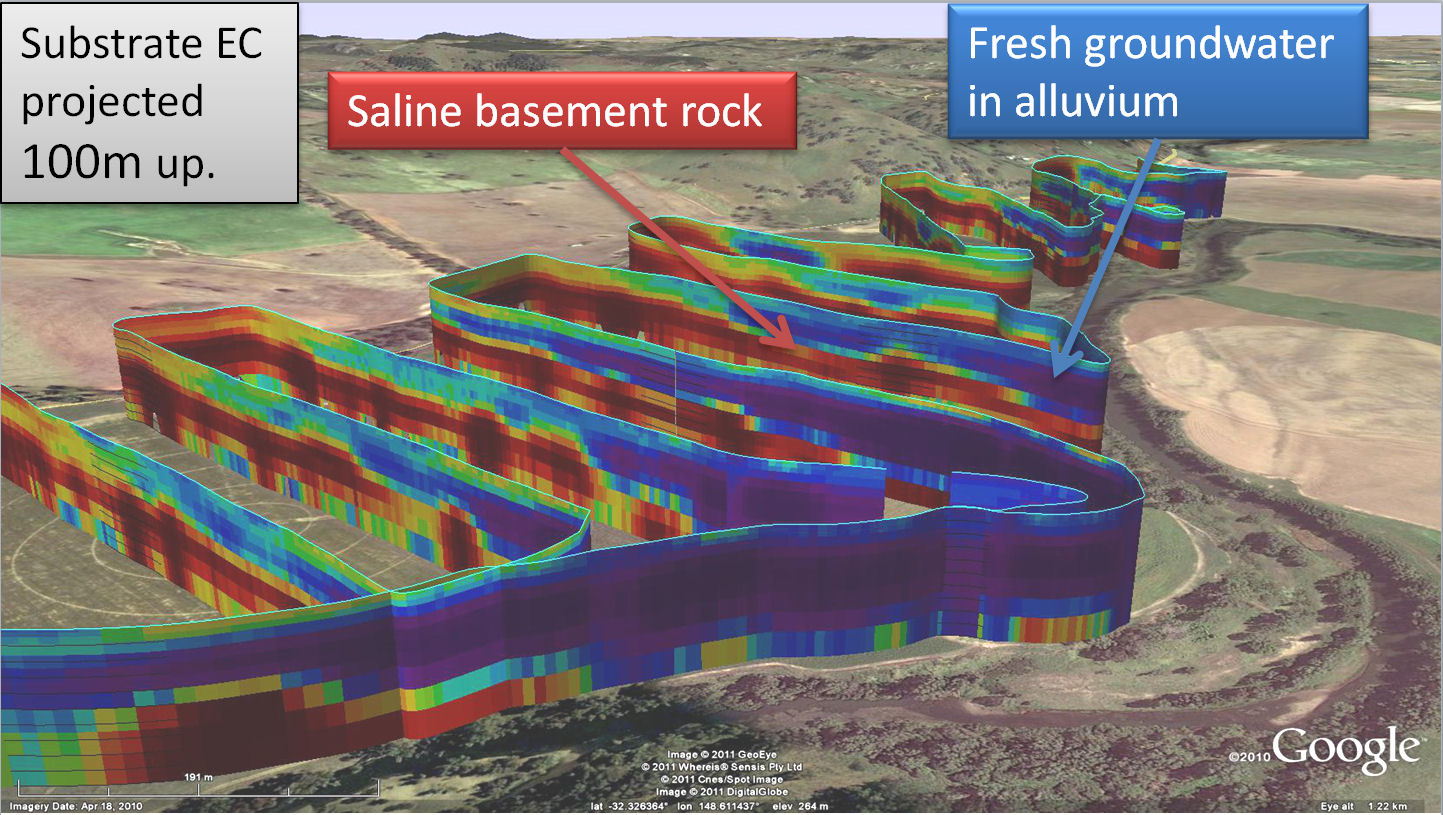 Two hours of towed TEM imaging has quickly revealed hidden groundwater related features under this farm.
Towed TEM - Mapping with Wallaby and Wallaroo systems
Two hours of towed TEM imaging has quickly revealed hidden groundwater related features under this farm.Towed TEM - Mapping with Wallaby and Wallaroo systems
Groundwater Imaging offer technology for quickly, but indirectly, investigating groundwater distribution and salinity at farm scale yet such survey is only warranted in certain circumstances. By towing a set of antennae on a non-magnetic trailer back and forth across a farm, typically, about 25km of survey, to a depth of 50 to 100m, will be conducted in one day. We can image deeper but this can be costly as heavier equipment must be deployed. The deeper we image, the courser the resolution so thin aquifers deep underground may not be detected (sometimes there is a whole group of them and collectively they get detected). If your groundwater is hosted in buried stream sand or gravel deposits, or in fractures in hard rock, there is a good chance that we can drastically increase your chance of drilling in the best location, plus provide a much more comprehensive understanding of your resource and its limitations. In many cases geophysical survey will be of value not for just finding water but in precisely positioning bores in the deepest, thickest intersections of permeable strata such that pump drawdown is significantly reduced, influence on surrounding bores reduced, and identified, and considerable energy savings made. We are interested in investigating not only bore siting possibilities but also possibilities of improving aquifer recharge management on farms which is a way of ensuring that you predictably have extra water of suitable quality during droughts.
We do not have a ‘silver bullet’, we apply no magic, and as a result we can guarantee that if you have no decent groundwater on your property, we will not find it for you. Instead, we provide maps and some specific reasoning on how those maps may be interpreted. Although we typically supply exact sites for drilling for those that want decisions made for them, files are supplied you can open on a mobile phone in Google Earth so you can walk around your property while looking at where you are on the geophysical map. Our technique depends on contrast in electrical resistivity between aquifers and other sediment and rock – we get a picture of the subsurface and sometimes it is easy to interpret and sometimes we are left with ambiguity that needs to be resolved by drilling and other clues. A typical ambiguity occurs when we image a resistive meandering buried channel – is it a solid lava flow or a gravel and fresh water filled channel? After piecing together a few clues about the local geology, this sort of ambiguity is often resolved. On the 'Wallaby’ section of this website, there is a video presenting the type of data that is acquired in half a day – in this case the deepest part of a gravel and sand filled valley was identified.
Many farmers ask about water divining.
Our God given ability to reason should not be substituted with techniques that throw reason to the wind. A comprehensive and rather polite study on water dowsing is given in a somewhat forgotten document – Water Divining FACT or FICTION written in the 1950’s by an experienced hydrogeologist. This practice does not seem to have improved since then. If you want divine help with your water investigation then please seek guidance by prayer to God, described in the Bible, so you know from whom you seek such guidance. For rational and reasonable assistance with groundwater investigation we can help in ways we understand, or in some circumstances, simply let you know the meagre limits of information that we think can reasonably be obtained. Those trying to give Water Diving some form of academic credibility try to pretend it is a geophysical technique, typically talking diviner talk such as 'two underground streams cross' and using magical props such as bent wire or willow sticks. Geophysical technology can be oversold too to the point that it is not much different - the document New geophysics? Or bad geophysics? How to not be fooled. addresses this situation. The divine guidance I have received is the Bible which has passages such as 'to do ... work quietly and to earn ... own living' - 2 Thessalonians 3:12